SKYWARN® Net Activation Criteria
First to Activate, Last to Deactivate
SUMMER

While dynamics may point to widespread severity, with the SPC also indicating the probability for a given day, such storms may not even materialize.
For example, during summer 2025 in southeast Colorado, the Storm Prediction Center had twice listed a SLGT to ENH risk (levels 2 & 3 of 5) for widespread severe storms a day prior. On both mornings, the atmosphere appeared highly-primed for this severity, including baseball size hail and damaging winds. In both cases, much of SE Colorado saw few severe storms, with those that formed being further southeast and more localized.
Since Mother Nature plays by no rules beyond those within atmospheric dynamics, the CSWN activates the Colorado Severe Weather Operations Room on a case-by-case basis.
Activation depends on the obvious storm-producing criteria such as high dewpoints, CAPE values, and shear types & speeds in a given location or area. These values are most influential to thunderstorm development and severity, though other factors also contribute to severity.
Strong and severe thunderstorm outbreaks can precede Watch issuance by several hours. There may be dozens of such storms prior to a Severe Thunderstorm Watch. Sometimes, many Severe storms occur across a wide area with no Watch issued whatsoever. An outbreak often begins with SPS Strong Thunderstorm Advisories, which are sub-severe but can certainly be damaging.
We monitor Regional radar for these types of build-ups and weigh this against atmospheric favorability toward wider coverage and/or stronger storm development. Thus, we are first to activate with heads-up announcements of NWS Strong Thunderstorm Advisories, providing spotters and the public with an early warning. Usually, Advisory-level announcements are made for 2-3 such storms in a locality as this heads-up; followed by any subsequent Warnings for that locality.
WINTER

Winter storms are also handled on a case-by-case basis, when we lean toward Winter Storm Warnings but, especially, Blizzard Warnings. Due to the volatility of vegetation on the high plains, Elevated to Critical Fire Weather conditions and High Wind events are also factored in to the activation equation.
During these events, we additionally monitor road conditions & closures and fire reports. Because of the sudden, hazardous nature of squalls, Snow Squall Warnings are treated the same as Severe Thunderstorm Warnings.
In all cases, by segregating repeaters to the CO Severe Operations Room within an afflicted area, our goal is to provide additional communications capability to supplement EMCOMM and cell service.
As was the case with the Spring Fire in Huerfano County, Colorado during the summer of 2018, nearly ALL communication capability was lost, including EMCOMM and cell phone service.
Below are general activation guidelines.
We use two different sets of criteria to determine when SKYWARN® nets may activate, depending on the time of day.
During daylight hours - from 6 AM to 10 PM local time - the following criteria are used to determine the potential need for the SKYWARN® ham radio team to activate:
Damaging Wind Risk at or above 30%
Severe Hail Risk at or above 30%
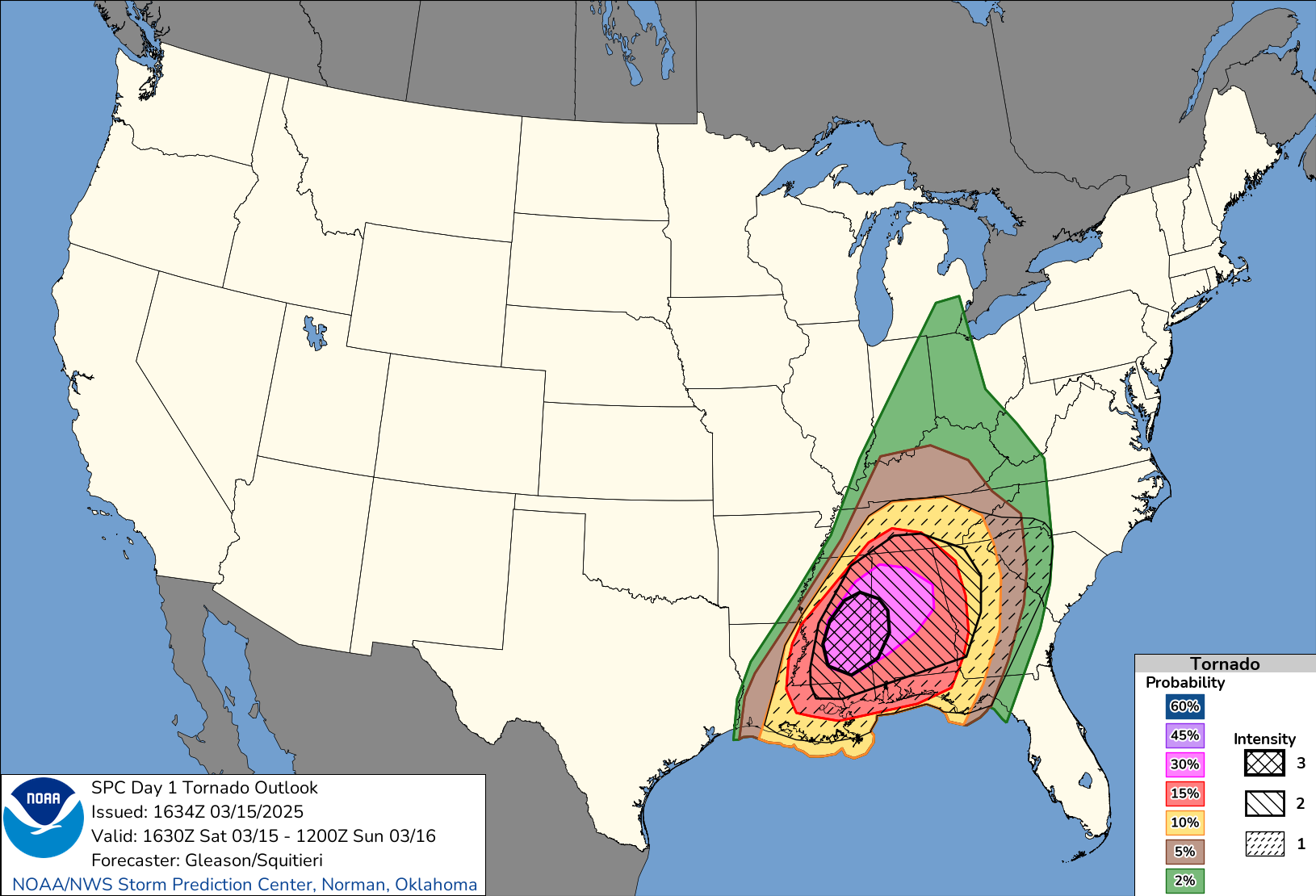
Tornado Risk at or above 10%
Particularly Dangerous Situation (PDS) Severe Thunderstorm or Tornado Watch issued
Winter Storm Warning issued
Upon request from the National Weather Service
When any of these conditions are met, SKYWARN® nets will prepare to activate and will go on the air once severe or potentially severe weather is impacting or about to impact the area, provided such weather conditions are occurring between the hours of 6 AM and 10 PM local time. The team will activate anytime there is a formal request from the NWS.
The team may be placed in a "standby" status when there is a threat of severe weather but the criteria provided here are not met. For example, a Severe Thunderstorm Watch with a 15% Damaging Wind Risk, 15% Severe Hail Risk, and 2% Tornado risk may result in a "standby" status to ensure team members are ready to activate in the event of localized hazardous weather which may warrant activation of SKYWARN.
Generally, if the wind, hail, and/or tornado risks levels are met on the Day 1 Convective Outlook, this should place the team in a standby status, with the issuance of a Watch, or the presence of locally severe weather conditions, serving as the trigger for net activation.
More restrictive criteria apply to activations between 10 PM and 6 AM and can be found in the SKYWARN® Operations Manual.
These criteria are designed to balance the needs of the National Weather Service with the needs and capabilities of the amateur radio community. We have designed these to ensure that we are on the air for significant weather events, avoiding excessive activations for the lower-impact events that historically have not generated enough traffic to even warrant having a net.
Regardless of how a weather scenario matches up with the criteria shown here, every trained CSWN SKYWARN® Net Controller has the authority to start a net any time they feel one may be needed. Likewise, the National Weather Service has the authority to request amateur radio support without regard for our own criteria.
Any questions about the criteria, or any suggestions can be directed to the CSWN STARS Team
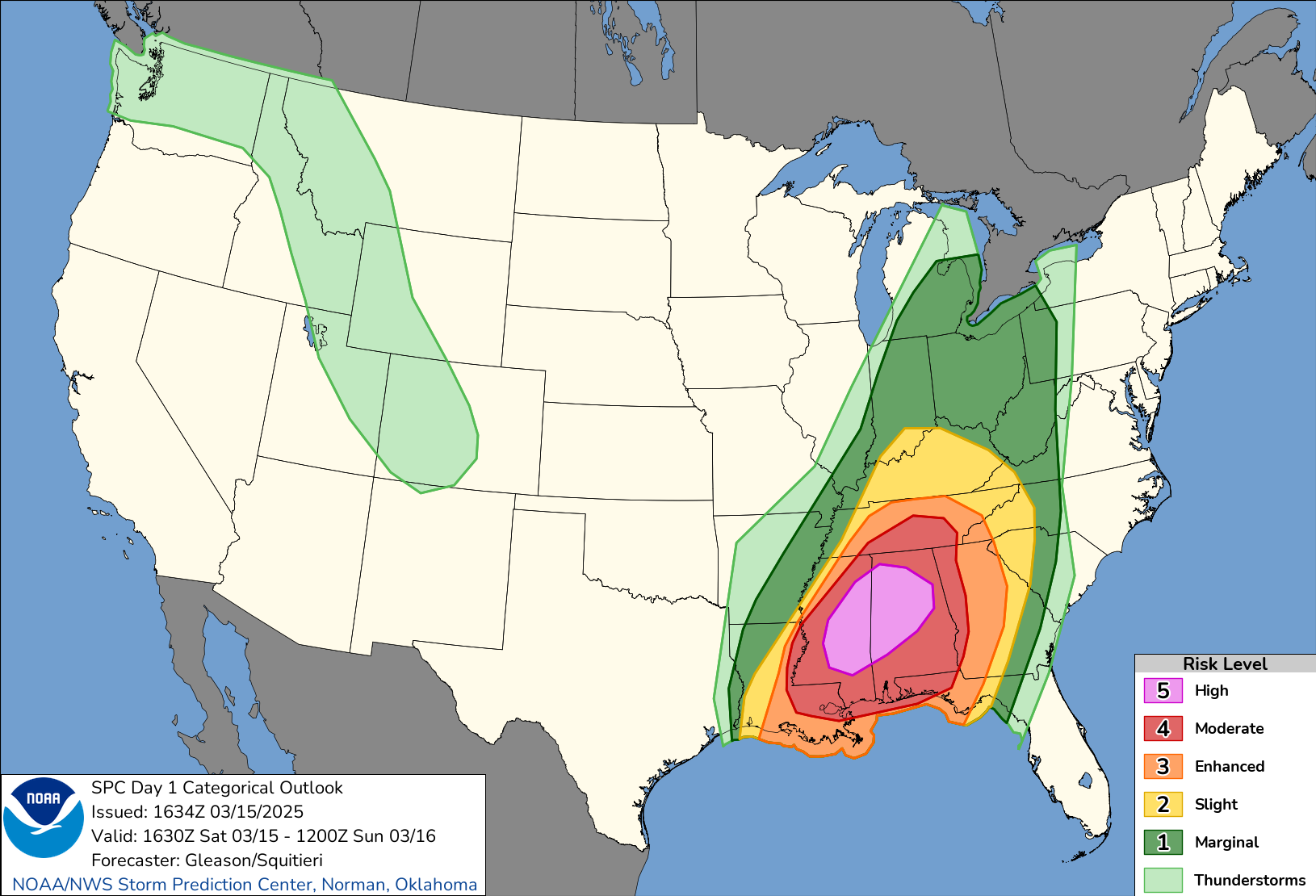
Convective Outlooks
SPC issues Day 1, Day 2, and Day 3 Convective Outlooks that depict non-severe thunderstorm areas and severe thunderstorm threats across the contiguous United States, along with a text narrative. The categorical forecast specifies the level of the overall severe weather threat via numbers (e.g., 5), descriptive labeling (e.g., HIGH), and colors (e.g., magenta). The probabilistic forecast directly expresses the best estimate of a severe weather event occurring within 25 miles of a point. The text narrative begins with a listing of severe thunderstorm risk areas by state and/or geographic region. This is followed by a concise, plain-language summary of the type(s) of threat along with timing that is focused on the highest-risk areas. The rest of the outlook text is written in scientific language for sophisticated users. This technical discussion usually includes a synopsis section to provide a general overview of the weather pattern, emphasizing features that will influence the severe and general thunderstorm threats. Additional sections of the discussion are usually separated by geographic areas. Within these individual geographic areas, the text offers meteorological reasoning and justification for the type of coverage and intensity attendant to the severe weather threat.
SPC also issues a Day 4-8 Severe Weather Outlook that similarly depicts severe thunderstorm threats across the contiguous United States and contains a technical discussion.
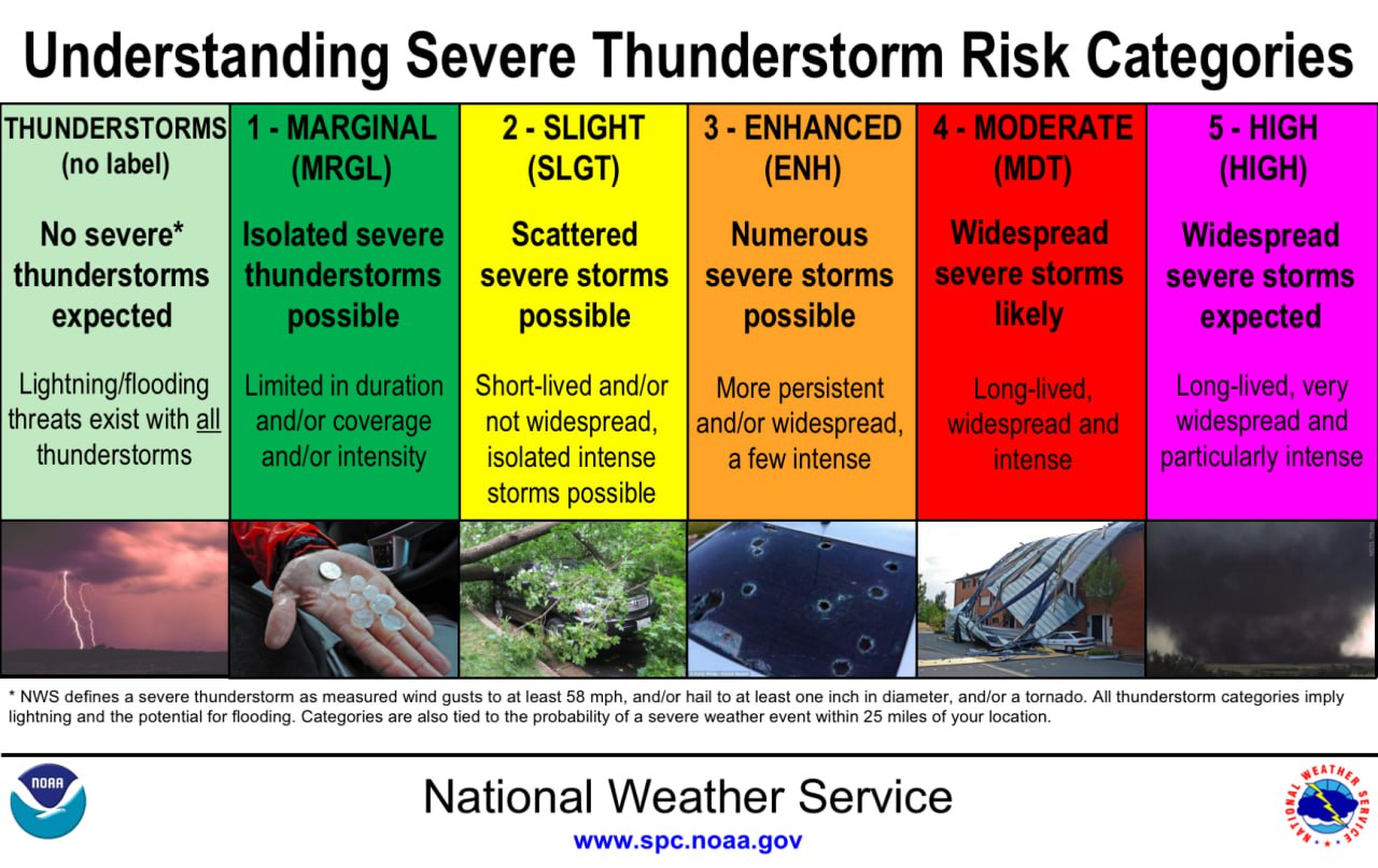
Severe Weather Risks
The level of categorical risk in the Day 1-3 Convective Outlooks is derived from probability forecasts of tornadoes, damaging winds, and large hail on Days 1 and 2, and a combined severe weather risk on Day 3.
- TSTM (light green) - General or non-severe thunderstorms - Delineates, to the right of a line, where a 10% or greater probability of thunderstorms is forecast during the valid period.
- 1-MRGL (dark green) - Marginal risk - An area of severe storms of either limited organization and longevity, or very low coverage and marginal intensity.
- 2-SLGT (yellow) - Slight risk - An area of organized severe storms, which is not widespread in coverage with varying levels of intensity.
- 3-ENH (orange) - Enhanced risk - An area of greater (relative to Slight risk) severe storm coverage with varying levels of intensity.
- 4-MDT (red) - Moderate risk - An area where widespread severe weather with several tornadoes and/or numerous severe thunderstorms is likely, some of which should be intense. This risk is usually reserved for days with several supercells producing intense tornadoes and/or very large hail, or an intense squall line with widespread damaging winds.
- 5-HIGH (magenta) - High risk - An area where a severe weather outbreak is expected from either numerous intense and long-tracked tornadoes or a long-lived derecho-producing thunderstorm complex that produces hurricane-force wind gusts and widespread damage. This risk is reserved for when high confidence exists in widespread coverage of severe weather with embedded instances of extreme severe (i.e., violent tornadoes or very damaging convective wind events).
Adding Intensity Information to SPC Convective Outlooks
Additional intensity information will be added to SPC convective outlooks for Day 1, 2, and 3 on March 3 starting with the 1630Z Day 1 Convective Outlook. The outlook categories will not change and should happen in a similar frequency to the past. Intensity will now be "conditional" (meaning if a tornado/wind gust/hail report occurs, how strong/intense/large do we expect it to be) and represented by 3 intensity levels (2 for hail) on the individual hazard graphics (second image). The categorical outlook graphics will have a visual update (including text: moving labels from the image to a legend) but will otherwise represent the same expected impacts from each category as before (see first image).