North Platte SKYWARN® & CWA Information
Office & CWA Overview
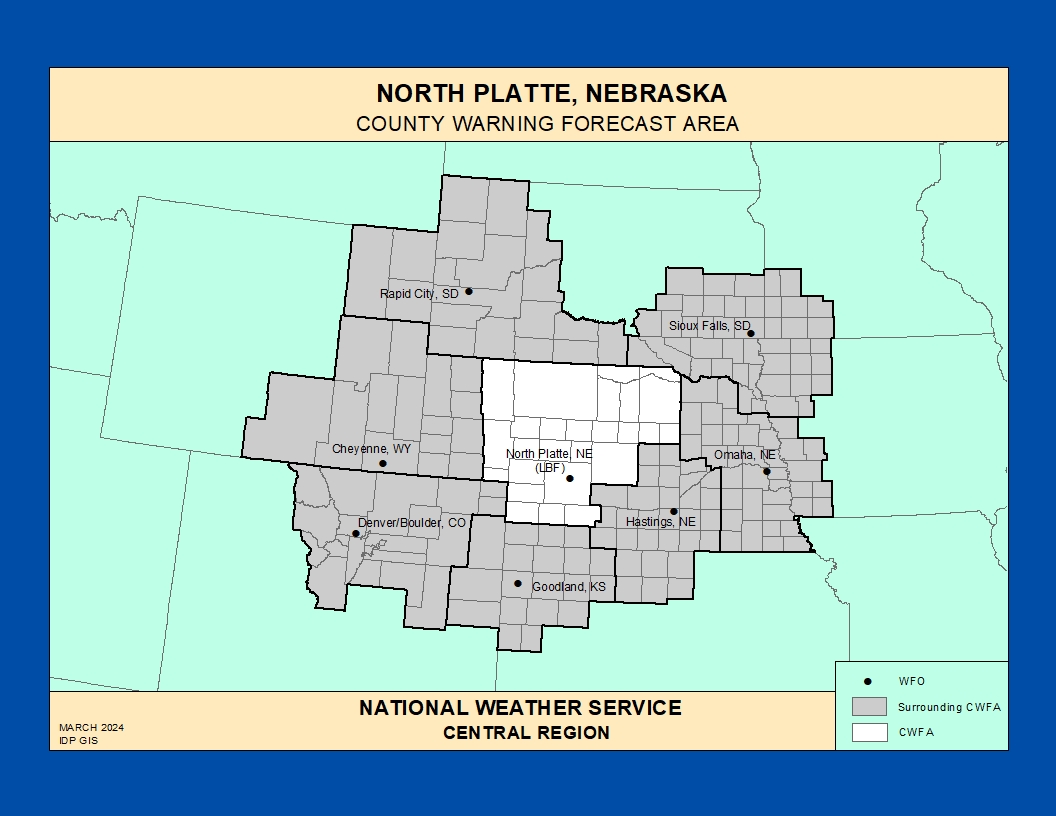
The National Weather Service Weather Forecast Office (WFO) in North Platte, Nebraska provides forecasts, warnings, and decision support services for a large portion of western and north‑central Nebraska, including the Sandhills, Platte River Valley, and adjacent High Plains ranch and farm country.
This County Warning and Forecast Area (CWFA) experiences a wide range of hazardous weather: major winter storms and blizzards, dangerous cold waves, severe thunderstorms with large hail and tornadoes, flash flooding on creeks and rivers, and episodes of critical fire weather driven by strong winds and dry fuels.
https://www.weather.gov/pimar/CWAbyWFO
Click here for the North Platte Area Photo Gallery!Historic Weather & Office Background
Weather observations and warning services in the North Platte area date back to early Weather Bureau and railroad operations that monitored blizzards, cold waves, and severe storms across the central High Plains and Sandhills of Nebraska.
Over time, the office evolved into today’s NWS North Platte Weather Forecast Office located at North Platte Regional Airport, supporting aviation, agriculture, ranching, transportation, and local communities throughout the CWFA.
The office now combines surface observations, satellite and radar data, and public and cooperative reports to provide forecasts, warnings, and decision support for emergency management and partners across western and north‑central Nebraska.
Nebraska Severe Weather Awareness
NWS North Platte , Cheyenne, Goodland, Hastings, Sioux Falls, and Omaha.
Notable Historic Weather Events in the NWS North Platte CWA
Late 19th Century Blizzards & Extreme Cold
In the late 1800s, multiple winter storms brought heavy snow, high winds, and deep drifts to the North Platte region, blocking trains and isolating homesteaders across the High Plains.
Notable events include November 1885 and March 1886 storms that produced 4 to 8 inches of snow with 4 to 6 foot drifts, delayed rail traffic, and caused livestock losses and hardships for settlers.
Record Cold – February 12, 1899
During the historic February 1899 cold wave, North Platte recorded a temperature of 35 degrees below zero, the coldest value on record for the city.
This extreme cold episode illustrates the vulnerability of ranching and rural communities to arctic outbreaks across the central Plains.
Early 20th Century Winter Storms
A winter storm on March 19–20, 1912 deposited 14 inches of snow at North Platte with strong winds, producing significant blowing and drifting as temperatures plunged from the 40s into the single digits below zero.
Travel disruptions, isolated rural residents, and impacts to livestock were common outcomes during these high‑impact winter storms.
North Platte Tornado & Railroad Impacts
Historical accounts describe a tornado passing just outside North Platte, overturning houses, blowing down windmills, damaging outbuildings, and heavily damaging Union Pacific Railroad facilities in a narrow but intense path of destruction.
Parts of the railroad roundhouse roof reportedly weighing up to several tons were carried hundreds of feet, killing one worker and injuring others, highlighting the severe tornado potential across the region.
Severe Thunderstorms & Tornadoes on the Plains
From late spring through summer, severe thunderstorms affect the North Platte CWA with large hail, damaging winds, and occasional tornadoes across the Sandhills, Platte River Valley, and surrounding plains.
Long‑lived supercells and squall lines can travel many miles, impacting agriculture, ranch operations, small towns, and major transportation corridors such as Interstate 80.
Flooding, Rivers, & the Platte System
Heavy rain events and snowmelt can lead to rises on rivers and creeks in the North Platte CWFA, including portions of the Platte River system and tributaries flowing through the Sandhills and surrounding plains.
Localized flash flooding in low‑lying areas, along small streams, and near road crossings remains an important warm‑season hazard for communities and travelers.
Fire Weather & High Wind Events
Periods of strong winds, very low humidity, and dry grasses and rangeland can create critical fire weather conditions across western and north‑central Nebraska, especially during dry springs and falls.
Rapid fire spread, reduced visibility due to smoke and blowing dust, and erratic wind shifts pose hazards to firefighting operations, travel, and nearby communities.
Explore additional historic weather information and event summaries for western
and north‑central Nebraska on the
NWS North Platte historical events page
.
North Platte SKYWARN® & Spotter Program
The North Platte WFO maintains a SKYWARN® storm spotter network across western and north‑central Nebraska, including trained volunteers in ranching areas of the Sandhills, farming communities along the Platte River, and towns along major highways such as Interstate 80.
Spotters include amateur radio operators, emergency management, law enforcement, fire and EMS, transportation and utility crews, and engaged citizens who provide real‑time reports during severe storms, winter weather, flooding, and fire weather events.
Official North Platte Office Page
Links to local forecasts, radar, climate information, and public outreach and preparedness material for the North Platte CWFA.
Spotter & Preparedness Resources
Preparedness pages cover thunderstorm, tornado, flood, winter, and fire safety, along with SKYWARN®, StormReady, and storm report information.
Colorado Severe Weather Network
Amateur radio–based severe weather support for NWS offices across the central Rockies and High Plains, including coordination opportunities that can involve the North Platte region during broader regional events.
Training & Reference for Spotters
Use these resources to build and refresh SKYWARN® skills tailored to the Sandhills, Platte River Valley, and open plains of the North Platte CWA.
- Convective storms – Supercells, squall lines, landspout and tornado potential on the plains, large hail, and downburst winds affecting ranches, farms, and small towns.
- Winter weather – Heavy snow, blowing and drifting, ground blizzards, and dangerous wind chills that can quickly impact travel and livestock.
- Hydrology – Flash flooding in low spots and along creeks and rivers, ice jams, and snowmelt‑driven rises on the Platte River and tributaries.
- Fire weather – Strong winds, low humidity, rapid grass and rangeland fire spread, and smoke and dust reducing visibility along highways.
Additional online modules, recorded talks, and case studies will be linked here as more North Platte–specific training material becomes available.
Significant Weather Event Reporting Criteria
National Weather Service – North Platte Forecast Office
How to Report
- Online: NWS Storm Report Form
- Spotter Hotline: Check local NWS North Platte spotter or EM materials for the latest phone contact.
- Email: Use contact options provided on the NWS North Platte website or through local emergency management channels.
- Social Media: Tag or message the NWS North Platte social media accounts when appropriate, following NWS guidance.
Flooding, Flash Flooding & Heavy Rain
- Rapid rises in streams, creeks, or low‑lying areas
- Water flowing faster or higher than normal
- Water threatening or covering roads, homes, or infrastructure
- One inch or more of rain in a short period
- Debris flows or erosion, especially in areas of steep terrain, burn scars, or along river banks
Winter Weather
- Measured snowfall amounts and time period
- Snow depth measurements and drift depths
- Blowing snow, whiteout, or blizzard conditions
- Freezing rain, ice accumulation, or significant glaze
Fire Weather
- New wildfire starts or rapid fire growth
- Smoke reducing visibility below 2 miles
- Strong, erratic winds affecting fire behavior
Convective / Thunderstorm Weather
- Tornado / Landspout: Rotating column of air touching the ground
- Funnel Cloud: Rotating, not touching the ground
- Wall Cloud: Persistent lowering from storm base
- Hail: Any size (include measurements and comparison objects)
- Wind: Damage, downed trees or power lines, or ~50 mph or greater
High Wind & Dust
- Widespread blowing dust reducing visibility
- Wind‑blown damage to structures, signs, or vehicles
- Transport trucks or high‑profile vehicles blown over or off the road